Source: Charlotte Mecklenburg Historical Landmarks Commission
The growth and expansion of Charlotte in the late nineteenth and early twentieth centuries were intimately bound up with the installation and development of its streetcar network. Streetcars initially appeared in Charlotte in January 1887, when a horse-drawn system commenced operations.1 It was the Charlotte Consolidated Construction Company, locally known as the Four Cs which revolutionized the transportation facilities of Charlotte, however. In February 1891, the Four Cs signed a $40,000 contract with the Edison Electric Co. to construct an electric streetcar on trolley system.2 Work began in march and terminated on May 18, 1891, when the first trolley departed from Independence Square, the intersection of Trade and Tryon Sts. in the heart of Charlotte.3 The system consisted of two lines, one from the Richmond and Danville Railroad Depot Carolina Central Railroad Depot on N. Tryon St. to Latta Park in Dilworth, the streetcar suburb which the Four Cs opened May 20, 1891.4
The accessibility of residential property to the trolley system became indispensable for successful real estate ventures in Charlotte after 1891. The initial expansion of the electric streetcar network occurred in September 1900, when a line opened which extended through Fourth Ward to Elmwood Cemetery on the western edge of the city.5 In May 1901, the Four Cs began service on a line which meandered through First Ward or the northeastern quadrant of Charlotte.6 In March 1902, trolleys initiated service to Piedmont Park, Charlotte’s second streetcar suburb.7 On December 13, 1902, the Charlotte Consolidated Construction Company opened a streetcar line which extended approximately three-fourths of a mile from the intersection of East Ave. (now E. Trade St.) and McDowell St. along Elizabeth Ave. to a point three hundred feet west of the main building of Elizabeth College, thereby providing a powerful impetus for the growth of Elizabeth as an affluent residential district.8
The Elizabeth College streetcar line enhanced the prospects for real estate development in the surrounding countryside including the farms along Providence Rd. Among the more prominent residents of this area was J. S. Myers, whose farm embraced approximately 1200 acres. In 1902, his daughter, Sophie, married George Stephens. This was to be a propitious connection for Charlotte’s future.
George Stephens was a talented, sensitive and gregarious man. A native of Guilford Co., North Carolina, he entered the University of North Carolina in 1892, where he excelled as a student and as an athlete. Indeed, he was offered a contract as a professional baseball player because of his prowess as a pitcher. Stephens decided instead to move to Charlotte following his graduation in the mid 1890s. Having written his senior thesis on the subject of road paving materials, he was attracted to Mecklenburg County because of its reputation for good roads.10 In 1899, he joined with F. C. Abbott in establishing Abbott & Stephens, a real estate firm. In 1901, Stephens became vice-president of tile Piedmont Realty Co., the developers of Piedmont Park. Also in 1901, he, Abbott, B. D. Heath and Word H. Wood founded the Southern States Trust Co., later the American Trust Co., of which Stephens became president following F. C. Abbott’s withdrawal from the company in 1902.11
In 1905, George Stephens brought John Nolen (1869-1937), who was to become one of America’s premier landscape architects and comprehensive planners, to Charlotte to design Independence Park, the first public park in the city. Interestingly, this was Nolen’s initial job. He was still a student in the School of Landscape Architecture at Harvard University.12 During his sojourn in Charlotte, Nolen commented that Stephen’s father-in-law, J. S. or “Jack” Myers, resided on a farm which had enormous potential as a residential development. It is reasonable to infer that this observation, coming as it did from such an impressive source, made a profound impression upon George Stephens. Jack Myers had long dreamed that his 1200-acre farm might become a fashionable residential development. However, he lacked the business skill that was necessary to achieve this objective. That was the ingredient which his talented, astute, and earnest son-in-law, George Stephens was to provide.
In 1911, George Stephens became the founder and president of the Stephens Co., a real estate firm committed to transforming the Myers Farm and certain contiguous parcels into a lavish, sophisticated suburb.14 Not surprising, Stephens selected John Nolen as the landscape architect who would design Myers Park. On November 6, 1911, the Charlotte Evening Chronicle reported that Nolen had had “the tract in hand for some time.” According to the Chronicle of December 30, 1911, the scope of Myers Park was “one of the biggest ever undertaken in this section of the South.”16 “In residential developments of this character we get a good idea of what can be done by municipalities in beautifying the cities of the country,” John Nolen asserted.17 On March 13, 1912, the Charlotte Observer exclaimed that Myers Park could be “a suburb of surpassing elegance and attractiveness.”18 This expectation would be fulfilled.
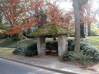
Among the essential amenities of Myers Park was a streetcar line. Grading for the line was well under way by February 1912, and trolleys began serving the suburbs on September 1, 1912.19 The Myers Park line branched off from the Elizabeth College line at the intersection of Elizabeth Ave. and Hawthorne Ln. and extended southward into the suburb, entering Myers Park at the intersection of E. Fourth St. and Queens Rd.20 On August 29, 1912, the Charlotte Observer announced that the Stephens Co. would erect a “combination gate and waiting station on any car line in the South,” the Charlotte Observer asserted.22 The contractor, J. A. Gardner, brought granite from Winnsboro, SC for the job. The waiting station and gate were completed by late September or early October 1912.23 The waiting station at the intersection of Queens Rd. and Hermitage Rd. was erected soon thereafter. 24 One cannot definitively attribute these structures to John Nolen. However, logic suggests that he would have designed landscape features of this order of magnitude. In the opinion of the Charlotte Observer, the entrance gate was waiting stations typified the elegance of Myers Park. “The expenditure of money which the Stephens Company is putting into the feature, largely ornamental, is an illustration of the care which is being taken to secure artistic finish in every detail,” the newspaper stated.25
Myers Park prospered. John Nolen sent landscape architects to Charlotte to prepare site plans for the purchasers of lots in the suburb. The Stephens Co. provided this service, thereby underscoring its commitment to excellence in fashioning its streetcar suburb. In 1915, Earl S. Draper, an associate of Nolen’s, located in Charlotte and oversaw the planting of trees along the streets of Myers Park. George Stephens resigned as president of the Stephens Co. in July 1922 and moved to Asheville, NC.25 Streetcar service in Charlotte terminated on March 12, 1938.27 Sometime thereafter, the entrance gate to Myers Park was demolished.28 However, the waiting stations at the entrance and the one at Hermitage Rd. and Queens Rd. survive.29
Footnotes:
1 The Charlotte Home Democrat (January 7, 1887), p. 3.
2 The Charlotte News (February 12, 1891), p. 1.
3 The Charlotte News (March 17, 1891), p. 3. The Charlotte News (May 19, 1891), p. 1.
4 The Charlotte News (May 21, 1891), p. 1. The Morning Star (Wilmington, NC) (May 22, 1891), p. 1.
5 The Charlotte Observer (September 20, 1900), p. 5.
6 The Charlotte Observer (May I5, 1901), p. 5.
7 The Charlotte Observer (March 21, 1902), p. 5.
8 The Charlotte Observer (December 13, 1902), p. 6.
9 “Charlotte – Real Estate and Subdivisions. Myers Park” a folder in the vertical files of the Carolina Room of the Charlotte-Mecklenburg Public Library. Hereafter cited as Myers Park. “Stephens, George (Mr. and Mrs.)” a folder in the vertical files of the Carolina Room of the Charlotte-Mecklenburg Public Library. Hereafter cited as Stephens.
10 Stephens.
11 F. C. Abbott, Fifty Years in Charlotte Real Estate (Charlotte, N.C., n.d.). A monograph in the Charlotte-Mecklenburg Public Library. For additional information on Word H. Wood, see Dr. Dan L. Morrill, “Survey and Research Report on the Wood-Platt House” (prepared on October 30, 1978, for the Charlotte-Mecklenburg Historic Properties Commission).
12 Myers Park. Robert Livingston Schlyler, ed., Edward T. James, assoc. ed., Dictionary of American Biography (Charles Scribner’s Sons, New York, 1958), Vol. 22 (Supplement Two), pp. 490-491.
13 Myers Park. Stephens.
14 For the major acquisitions of the Stephens Co., see Mecklenburg County Deed Books 268, p. 353; 277, p. 189; 268, p. 597; 280, p. 41; 280, p. 201; 277, p. 638; 276, p. 496; 283, p. 222; 276, p. 508; 283, p. 337; 280, p. 491. For maps or the locations of the waiting stations, see Mecklenburg County Map Book 230 p. 122 & 124.
15 Charlotte Evening Chronicle (November 6, 1911), p. 6
16 Charlotte Evening Chronicle (December 30, 1911), p. 1.
17 The Charlotte Observer (March 21, 1912), p. 7.
18 The Charlotte Observer (March 13, 1912), p. 6.
19 The Charlotte Observer (February 8, 1912), p. 6. (September 2, 1912), p. 5.
20 Charlotte Evening Chronicle (November 6, 1911), p. 6. Initially known as the Boulevard, Queens Road acquired its name in February 1913 in honor of Queens College, which would be locate at the southern terminus of the thoroughfare (Charlotte Observer [February 1, 1913], p. 7). John Nolen also designed the Queens College Campus (Charlotte Observer [March 22, 1912], p. 6).
21 The Charlotte Observer (August 29, 1912), p. 6.
22 The Charlotte Observer (September 2, 1912), p. 5.
23 The Charlotte Observer (August 29, 1912), p. 6.
24 The Charlotte Observer (October 10, 1912), p. 5. Technically, Hermitage Court was not part of Myers Park. It was developed by the Simmons Co., not the Stephens Co.
25 The Charlotte Observer (August 29, 1912), p. 6.
26 Myers Park. Stephens.
27 The Charlotte Observer (March 13, 1938), p. 1.
28 For a photograph of the entrance gate, see William T. Simmons and L. Brooks Lindsay, Charlotte and Mecklenburg County: A Pictorial History, (Donning Co., Norfolk, VA., n.d.), p. 59. It should be noted that this volume contains many errors.
29 Local residents recall that there were other waiting stations on the Myers Park line. None, however, survive.
7. A brief architectural description of the property: This report contains an architectural description of the property prepared by Jack O. Boyte, A.I.A.
8. Documentation of why and in what ways the property meets the criteria set forth in N.C.G.S.160A-399.4:
a. Special significance in terms of its history, architecture, and/or cultural importance: The Commission judges that the property known as the Myers Park Streetcar Waiting Stations does possess special significance in terms of Charlotte-Mecklenburg. The Commission bases its judgment on the following considerations: 1) they conform to the plan devised by John Nolen, a landscape architect of national renown; 2) they have strong associative ties with George Stephens, an individual of local and regional importance; 3) they are the only surviving elements of the Myers Park streetcar line and, except for a substantially altered streetcar barn in Dilworth, of the entire Charlotte streetcar system, which served this community from May 1891 until March 1938.
b. Integrity of design, setting, workmanship, materials, feeling, and/or association: The Commission judges that the architectural description included herein demonstrates that the property known as the Myers Park Streetcar Waiting Stations meets this criterion.
9. Ad Valorem Tax Appraisal: The Commission is aware that designation would allow the owner to apply annually for an automatic deferral of 50% of the Ad Valorem taxes on all or any portion of the property which becomes “historic property.” The subject property is owned by the City of Charlotte and is, therefore, not subject to Ad Valorem taxes.
Bibliography
F. C. Abbott, Fifty Years In Charlotte Real Estate (Charlotte, NC, n.d.).
Charlotte Evening Chronicle.
The Charlotte Home Democrat.
The Charlotte News
The Charlotte Observer
“Charlotte – Real Estate and Subdivisions. Myers Park. “A folder in the vertical files of the Carolina Room of the Charlotte-Mecklenburg Public Library.
The Morning Star (Wilmington, NC).
Dr. Dan L. Morrill, “Survey and Research Report on the Wood-Platt House.” (Prepared on October 30, 1978, for the Charlotte-Mecklenburg Historic Properties Commission.
Records of the Mecklenburg County Register of Deeds Office.
Records of the Mecklenburg County Tax Office.
Robert Livingston Schlyler, ed., Edward T. James, assoc. ed., Dictionary of American Biography (Charles Scribner’s Sons, New York, 1958), Vol. 22 (Supplement Two).
William T. Simmons and L. Brooks Lindsay Charlotte and Mecklenburg County: A Pictorial History (Donning Co., Norfolk, VA, n.d.).
“Stephens, George (Mr. and Mrs.)” a folder in the vertical files of the Carolina Room of the Charlotte-Mecklenburg Public Library.
Date of preparation of this report: June 4, 1980.
Prepared by: Dr. Dan L. Morrill, Director
Charlotte-Mecklenburg Historic Properties Commission
3500 Shamrock Dr.
Charlotte, NC 22215
Architectural Description
By Jack O. Boyte
On the southeastern fringe of Charlotte a new residential subdivision was spread across rolling farm land in the first decade of this century. This neighborhood called “Myers Park” was designed by landscape architect John Nolen to include convenience as well as beauty and comfort. A primary convenience, advertised by the developers, was easy access to the new electric trolley which snaked through the subdivision in a landscaped median. No house lot was to be more than two blocks from the street car. Furthermore, shelters were erected at regular intervals along the line to protect waiting commuters; a line which reached as far as the Queens College campus. Three of the original shelters remain much as they were when new in 1912. Two of these shelters identify the original subdivision gateway at the intersection of East Fourth Street and Queens Road. Here there was a large center trolley shed, since demolished, through which double tracks entered the grass median. Smaller sheds at each side of the divided street covered the paved walks. These flanking shelters anchor semi-circular low stone walls which flare out further to give a grand scale to this main Myers Park entrance. On the east side of the intersection at Queens and Hermitage Roads is the third shelter, also remarkably preserved with most original material intact.
The three shelters have uniform design and detailing. The one remaining at Hermitage Road was intended to provide a covered bench waiting area, while those at Fourth Street are larger, more impressive gateway canopies. The structures have broad over hanging wooden roofs, twelve feet wide and eight feet front to back, resting on two large granite pillars. Unusual features on the Fourth Street shelter piers are small stone lugs projecting from three sides to support wood roof overhang knee brackets. Built of rough faced random ashlar, the sturdy piers rise more than eight feet to a bracketed rectangular frame. Above this is a low tripped roof covered with sawn cedar shingles. While not original, the wood roof surfaces have weathered to a soft gray patina consistent with the shelters’ years.
The wood superstructure is framed of finished 4 x 4s and 4 x 6s. Rafter ends are exposed and chamfered to align with a narrow fascia on the roof perimeter. There is a painted ceiling of 4 inch boards, beaded at the edge and center in the typical turn of the century manner. A small crown mold trims the ceiling edges.
The granite blocks, rough cut from the popular “blue” Winnsboro stone of the time, vary in size and shape. Chiseled edges abut in generally uniform joints which are tooled with a square edged rustication line designed to emphasize random coursing. The stone cork in the shelter pillars and curved gate walls is an exceptional example of the skilled stone masonry common at the turn of the century, and the original surfaces show no apparent deterioration.
The shelters have been carefully, and fortunately, preserved since the last trolley ran nearly forty years ago. Few changes have occurred, though the piers at Fourth Street have poorly built shoulder additions which should be removed, and one ceiling has been repaired with plywood instead of beaded ceiling boards. Otherwise, these fine little structures are in good condition and are significant architectural remnants from a colorful era in Charlotte’s recent history.
Addendum to the Survey and Research Report on the Myers Park Streetcar Waiting Stations
The Hermitage Court Gateways
1. Brief historical sketch of the property:
On February 28, 1912, the Charlotte Observer announced that Floyd M. Simmons of the Simmons Company, a local real estate firm, had purchased a tract of land which was contiguous with Myers Park, the elegant streetcar suburb which the Stephens Company had recently begun. John Nolen (1869-1937), the landscape architect for Myers Park, also designed Simmons’ development, which was named “Hermitage Court.”1 Hermitage Court opened on October 10, 1912.2 Among the amenities of the suburb were massive entrance gates at either end of the boulevard.3 “It is believed by the developers these gateways will lend a tone and exclusiveness to the suburb which could be derived in no other way,” the Charlotte Observer reported on March 21, 1912.4 Construction of the gateways was in progress by early September 1912.5 They were finished before the official opening of Hermitage Court on October 10, 1912. The Charlotte Observer was expansive in its description of these edifices: “At either entrance to Hermitage Court is a handsome granite gateway, pointed with red cement mortar, the work on these was done by two Scotchmen who came here for the purpose from Aberdeen Scotland last June. On one gate appears the inscription, “Ye Easte Gayte,” and on the other, “Ye Weste Gayte.” Many are designed after the entrance ways to Andrew Jackson’s old home near Nashville.”6
NOTES
1 Charlotte Observer (February 28, 1912), p. 6.
2 Charlotte Observer (October 10, 1912), p. 5.
3 For an early photograph of the western gate, see Charlotte Observer (November 3, 1912), p. 9.
4 Charlotte Observer (March 21, 1912), p. 6.
5 Charlotte Observer (September 2, 1912), p. 5.
6 Charlotte Observer (October 10, 1912), p. 5.
Date of preparation of this Addendum: July 2, 1980
Prepared by: Dr. Dan L. Morrill, Director
Charlotte-Mecklenburg Historic Properties Commission
3500 Shamrock Dr.
Charlotte, N.C. 28215
Telephone: (704) 332-2726
Architectural Description
Jack O. Boyte
A short distance beyond the imposing “Myers Park” entrance, a new subdivision was also opened in 1912 whose gateways matched the masonry design of the main “Myers Park” gate as well as the nearby trolley shelter at the intersection of Queens and Hermitage Roads. Borrowing the adjoining street name, as well as the granite “Myers Park” entrance details, Hermitage Court connected Hermitage Road to Highway 16 (Providence Road) which ran parallel to Queens Road about a half mile to the east. The new development had unique east and west gates. At each end of the long median divided street, the sidewalks and drives were flanked by massive granite piers and low curved walls which guarded and defined the new subdivision. This extraordinary stone work remains today undisturbed and still an impressive community feature.
From Hermitage Road one may walk into Hermitage Court between tall blue granite pillars at either side. Or vehicles can enter one way drives left or right which are also flanked by tall stone piers. The walkway gate piers are three feet square and rise seven feet to sloped stone peaks. In the center, a landscaped median with twin pillars and a connecting, low, undulating wall complete the impressive gateway. These center piers are four feet square and rise more than nine feet to stone caps which also slope up to low peaks. At the top are remnants of brass brackets which give evidence that at an earlier time the center piers were crowned with decorative lanterns. Small round granite wheel bumpers protrude from the base of all curb side piers.
At the east end of Hermitage Court is another gateway of massive granite pillars and low walls. This gateway faces Providence Road with the same impressive masonry details as those at the Queens-Hermitage Road end. The stone work in the twin entrances is similar to that found in the original trolley line gates and shelters. The rough face random granite ashlar is the same, and the joints show the same careful workmanship. However, pink colored mortar appears on the Hermitage Court stonework whereas, it is ordinary gray in the earlier Myers Park installations.
These remarkable old gateways represent a time when impressive entrance details were regularly used to define important boundaries. County lines, for entrance, were often graced with such structures. As rare survivors of that time and as significant elements in the early development of suburban “Myers Park,” the Hermitage Court granite gates are important architectural remnants.
property is found in Mecklenburg County Deed Book 3939 at page 288. The Parcel Number of the property is 153-063-05.